Belize 2010
Thursday, July 1, 2010, Santa Elena, Belize, about 1500 CST
(GMT-6)
We're off again on another adventure, this time to Belize. The
mission of this trip is not completely clear to me, but in part Sandy
wanted to travel and in part, Sandy's thesis advisor wanted some help
setting up a geographical data base for his field school this year.
Last year, we attended the Pambamarca field school in Ecuador, Sandy as
a student and I as staff. We were in Ecuador for 6 weeks. This year,
the field school is in Belize. I'm not yet sure what they are digging
up, but the school just started on Monday. We're not formally part of
the school this year but we're here anyway.
Belize used to be British Honduras before it became independent.
English is the formal language, but others are spoken. All signs are in
English and the roads use the American system as opposed to the British
system.
Our flight left LAX at 0125 on July 1, 2010. I didn't get a lot of
sleep on the airplane. We made a connection on TACA at San Salvador and
arrived in Belize City sometime before 0900 local time which is just
one hour ahead of PDT. It's actually two time zones but they don't do
daylight savings time here. We got a $25 US cab ride from the airport
back to the bus terminal in Belize City and got on a local bus to San
Ignacio. The ride was about 3 hours long and it stopped for everybody
that flagged the bus down, but it only cost $3.50/head US. The Belize
dollar is 2:1 for the US dollar but US dollars are taken
everywhere.
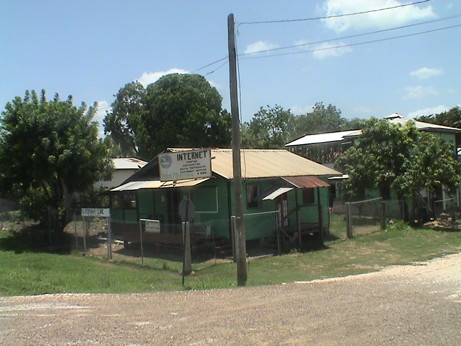 I didn't take many pictures from the
moving bus because those often don't turn out to well, but I snapped
this picture of a somewhat beat up house. When I reviewed the picture,
it noticed the Internet sign out front. Some houses were nicer than
this one, most were much worse. Some were no more than shacks. This is
not a rich country and people make do as they can.
I didn't take many pictures from the
moving bus because those often don't turn out to well, but I snapped
this picture of a somewhat beat up house. When I reviewed the picture,
it noticed the Internet sign out front. Some houses were nicer than
this one, most were much worse. Some were no more than shacks. This is
not a rich country and people make do as they can.
The terrain was mostly flat until we got near San Ignacio. It was
mostly swamp near Belize City, transitioning to scrub, then to a mixed
low forest and finally hilly country with either mixed forest or
jungle. Much of the land along the road did not appear to be developed
in any way at all.
The distance wasn't so long, maybe 75 miles, but the bus stopped
constantly to let riders on and off.
By the time we got to San Ignacio, my backside was pretty sore from
sitting on a poorly padded bus bench seat for 3+ hours. We got a cab
for $5 US from the bus terminal in San Ignacio to the Maya Mountain
Lodge, which is where we are now.
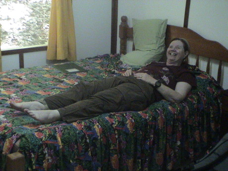 Sandy
collapsed onto the bed as soon as we got into the room. It didn't take
her long to fall asleep. I wandered around the lodge taking pictures
and trying to arrange contact with the field school project. That
hasn't happened yet, but about dinner time we are going to get a cab to
the hotel where the UCLA part of the project is staying to see if we
can get some face time with the project leader, Dr. Sam Connell.
Sandy
collapsed onto the bed as soon as we got into the room. It didn't take
her long to fall asleep. I wandered around the lodge taking pictures
and trying to arrange contact with the field school project. That
hasn't happened yet, but about dinner time we are going to get a cab to
the hotel where the UCLA part of the project is staying to see if we
can get some face time with the project leader, Dr. Sam Connell.
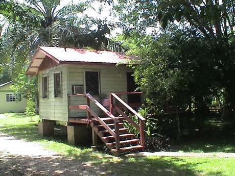
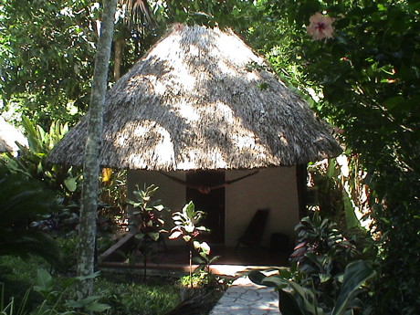 We have a more or
less standard hotel room with AC. For $10 more, we could have rented a
cottage like this one. The whole place is set into a tropical forest
environment There is a pool which I think that I am going to take
advantage of shortly after I finish writing this part of the page. It's
about 90°F and probably 80+% humidity outside so it is fairly
uncomfortable. The pool will feel good.
We have a more or
less standard hotel room with AC. For $10 more, we could have rented a
cottage like this one. The whole place is set into a tropical forest
environment There is a pool which I think that I am going to take
advantage of shortly after I finish writing this part of the page. It's
about 90°F and probably 80+% humidity outside so it is fairly
uncomfortable. The pool will feel good.
Thursday, July 1, 2010, Santa Elena, Belize, about 2130 CST
(GMT-6)
Instead of going into the pool, we elected to get a taxi to the
other side of town. This is actually two towns, Santa Elena is on the
eastern side of the Mecal River, San Ignacio is on the western side.
The Midas Resort, where the UCLA students are staying, is at the
western edge Santa Ignacio. We took a taxi over there (too far to walk)
and met with some old friends. We didn't find Sam Connell because he
was holed up in the house he is staying in writing a presentation that
he has to give tomorrow. Almost next door to the Midas Resort is
Hode's, a restaurant and bar. It is a big place, capable of seating at
least 200 people. We stopped there for lunch on a tour the last time we
were here. It was good. We had dinner there tonight and that was good
too.
Tomorrow, we are going to move over to the Midas Resort. It will
cost us less, especially for food. There is nowhere to eat anywhere
near here except for the Lodge dining room and that is $30/head/day.
Hode's is about $4 to $10 US per full meal. A good hamburger is $2.50
US. The Midas Resort is not in as nice a setting as the Maya Mountain
Lodge but the room will cost $35 less and the food $40 less (US
prices). We will also be right with the UCLA students and staff. It is
also walking distance into town and there is a supermarket of sorts
there.
Tomorrow, there is also a conference on Mayan Archaeology so the
students will be listening, not digging. They've just started marking
off their units, and have not actually gotten dirty yet. There is a
field trip planned for them on Saturday that doesn't include digging
and Sunday is an off day so they won't start really working again until
Monday.
Sandy and I have tentatively planned a trip across the border into
Guatemala on Sunday to go to Tikal, the tallest Maya structure yet
discovered. Starting Monday, Sandy will probably get down to work on
the GIS (Geographical Information Systems) stuff. What I do while Sandy
is busy working on their mapping software is TBD. I may go into the
field just to look around and perhaps help some of the students.
After we'd had dinner and reserved a room at the Midas Resort, we
called a taxi for the $5 US ride back to our hotel to spend the night.
Sandy will probably take a taxi early to the conference and I'll hang
out here until close to checkout time and bring our luggage (there
isn't a lot of it, two carry on suitcases and two backpacks) over to
the Midas Resort in another taxi and check in.
I didn't sleep much on the airplane last night and traveling is
exhausting anyway so I am beat. It will feel good to get a full night's
sleep tonight.
Friday, July 2, 2010, San Ignacio, Belize, about 1030 CST
(GMT-6)
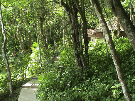 Sandy got up early this
morning and took a taxi to town to attend the presentations. I slept in
and then lounged around the Maya Mountain Lodge taking pictures like
this one from just outside the building that our room was in.
Sandy got up early this
morning and took a taxi to town to attend the presentations. I slept in
and then lounged around the Maya Mountain Lodge taking pictures like
this one from just outside the building that our room was in.
 Later, I checked out and
took a taxi to the Midas Resort and checked in. Our room is $26 less
expensive, we don't have to take taxis to get anywhere and the rest of
our group is here. Hode's is virtually next door so we can get meals.
The resort is not quite as nice as the Maya Mountain Lodge.
Later, I checked out and
took a taxi to the Midas Resort and checked in. Our room is $26 less
expensive, we don't have to take taxis to get anywhere and the rest of
our group is here. Hode's is virtually next door so we can get meals.
The resort is not quite as nice as the Maya Mountain Lodge.
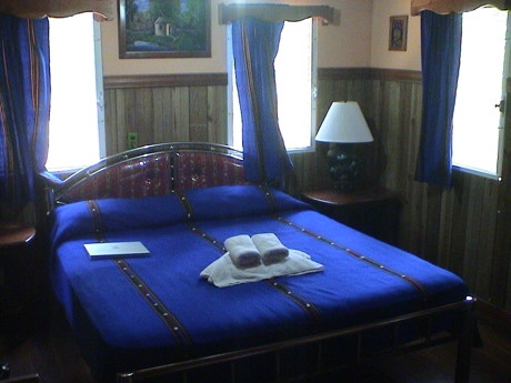 The room itself is a
little nicer inside than the one at Maya Mountain. It is larger, wood
paneled, has AC and a TV. The bed is larger too but not quite as
firm.
The room itself is a
little nicer inside than the one at Maya Mountain. It is larger, wood
paneled, has AC and a TV. The bed is larger too but not quite as
firm.
The one AC outlet not used by room appliances is above the bed
within reasonable reach to get to a small table on either side. The
only one at Maya Mountain was underneath the bed.
Right now, I'm sitting inside on the bed with the flow from the AC
blowing right across me. It's not too comfortable outside.
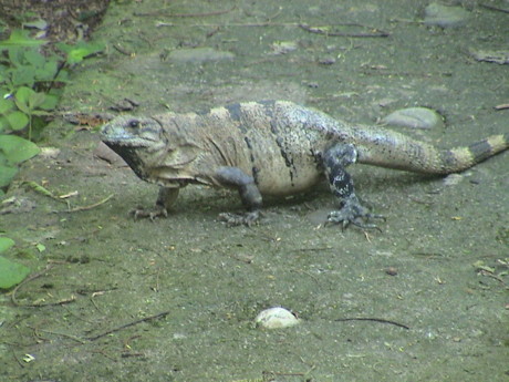 There are iguanas all over
the place of all sizes. I've already seen them from this big to ones
that are an inch long. The little ones may not be iguanas but they are
lizard like nonetheless. The iguanas get much larger around here, we
saw some really big ones the last time we were here.
There are iguanas all over
the place of all sizes. I've already seen them from this big to ones
that are an inch long. The little ones may not be iguanas but they are
lizard like nonetheless. The iguanas get much larger around here, we
saw some really big ones the last time we were here.
We've been in Belize for 24 hours or so and I haven't mentioned the
bugs yet. This is because there aren't many. There are some mosquitos
that bite, but not many and the bites don't itch for long. There are
all manner of ground dwelling insects, especially ants, but they don't
seem to be a bother either. Perhaps it will be worse out in the working
areas.
Sunday, July 4, 2010, San Ignacio, Belize, about 1700 CST
(GMT-6)
 I took a nap under the AC
and woke up about lunchtime. Sandy came back from the conference about
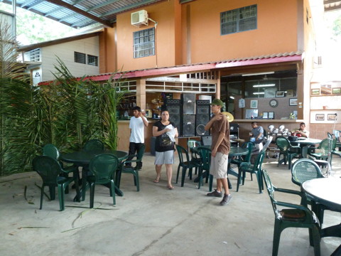
the same time we walked over to Hode's for lunch. This is Hode's, our
primary source of food. The project is providing us meals as we will be
doing work for them. We're paying for and our own room. Transportation
on non-project activities is also on our dime.
I took a nap under the AC
and woke up about lunchtime. Sandy came back from the conference about
the same time we walked over to Hode's for lunch. This is Hode's, our
primary source of food. The project is providing us meals as we will be
doing work for them. We're paying for and our own room. Transportation
on non-project activities is also on our dime.
The plan forward was to relax for the afternoon but we took a walk
into town to find a market for some non-perishable food and to look
around. San Ignacio looks pretty much like any Latin American town, a
little rough around the edges but functional.
Saturday, the project took a field trip to Caracol, a Maya ruin
south of San Ignacio in the Maya Mountains. This was a LONG trip, it
took all day. We didn't get back until well after dark and just getting
dinner consumed the rest of our energy. We just crashed.
It's now Sunday morning, an off day. We had planned to travel to
Tecal, a large ruin across the border in Guatemala, but we were so
tired that we elected to cancel it for today and just regain our
strength. We'll try to fit Tecal in later in the week. Tecal has the
tallest Maya structures and it is reported to be quite impressive.
Caracol is a very large Maya city, perhaps hosting 100,000 or more
people around AD 840 or so. It was only discovered a couple of decades
ago and the excavation and rebuilding has been going on for a little
more than 10 years. Caracol contains the largest Maya structure by
area. This temple is also the tallest building in all of Belize today.
We were guided through Caracol by the archaeologists, John and Mo, that
guided the excavation and restoration of Caracol.
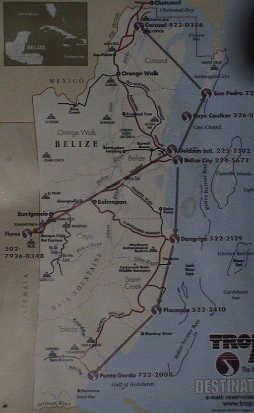 I found
this map of Belize in a travel magazine that was in our room at the
Midas Resort. There are really only three major roads in Belize. The
all radiate from Belize City which is centrally located on the
Caribbean coast. The Northern highway goes to the north into Mexico
where is connects to a Mexican highway that goes a long way west
cutting through the south end of the Yucatan and a lot of nowhere. The
Hummingbird/Southern Highway goes south toward the border to Guatemala,
but may not go much further than that, at least the maps that we have
don't show any roads. The Western Highway cuts southwest to San Ignacio
and the Guatemalan border. This appears to be the major land route into
Belize.
I found
this map of Belize in a travel magazine that was in our room at the
Midas Resort. There are really only three major roads in Belize. The
all radiate from Belize City which is centrally located on the
Caribbean coast. The Northern highway goes to the north into Mexico
where is connects to a Mexican highway that goes a long way west
cutting through the south end of the Yucatan and a lot of nowhere. The
Hummingbird/Southern Highway goes south toward the border to Guatemala,
but may not go much further than that, at least the maps that we have
don't show any roads. The Western Highway cuts southwest to San Ignacio
and the Guatemalan border. This appears to be the major land route into
Belize.
A highway here is a two lane road with a stripe down the middle (in
most places). There are other roads too, but many of them are dirt, as
we were to find out.
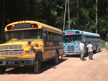 To get from San Ignacio
to Caracol, we boarded some school busses at about 0830 on Saturday,
July 3. These were clearly set up for children as the seats were so
close together, I couldn't get my knees in except at an extreme angle.
I was either hanging out into the aisle or impinging on Sandy's space.
We were in the larger blue one, an American made Blue Bird bus. A lot
of the intercity and local busses are the same kind, they must be
popular. Ours was a 1987 model that had obviously served somewhere else
before it came here.
To get from San Ignacio
to Caracol, we boarded some school busses at about 0830 on Saturday,
July 3. These were clearly set up for children as the seats were so
close together, I couldn't get my knees in except at an extreme angle.
I was either hanging out into the aisle or impinging on Sandy's space.
We were in the larger blue one, an American made Blue Bird bus. A lot
of the intercity and local busses are the same kind, they must be
popular. Ours was a 1987 model that had obviously served somewhere else
before it came here.
We took the Western Highway back east for 10 miles or so and then
turned south onto a road marked in black. It was paved for about half a
mile and then turned to dirt. The road was quite rough in spots, deeply
rutted and washboarded. The bus shook and shuddered quite a bit but
seemed to hold together. The trip to Caracol took more than 3 hours, we
got there just before noon.
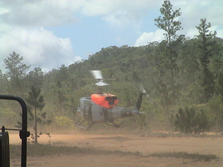 Along the way, we
stopped at a checkpoint and this British Army Huey flew in overhead and
landed. Several helicopters dropped off troops in full gear and picked
up more of them. I assume that they were doing jungle training. There
was an encampment a little further down the road guarded by armed
guards.
Along the way, we
stopped at a checkpoint and this British Army Huey flew in overhead and
landed. Several helicopters dropped off troops in full gear and picked
up more of them. I assume that they were doing jungle training. There
was an encampment a little further down the road guarded by armed
guards.
The last 10 miles of the road to Caracol was paved. Apparently, the
government started paving the road from the end first, then ran out of
money to finish the job. We were grateful for the good road though.
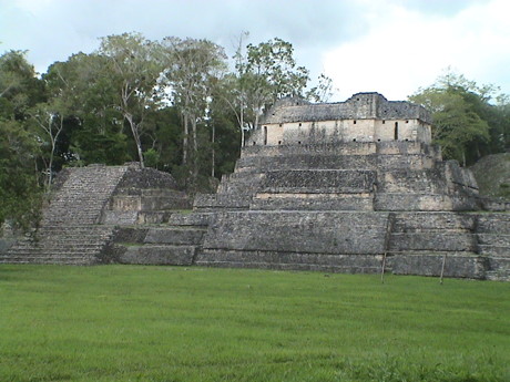
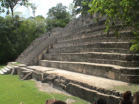 This is the largest structure at
Caracol, the main temple. When this was originally found, the
archaeologists hiked up and down a "hill" without actually realizing
that there was such a large structure underneath. Nobody expected to
find such a large complex this far away from the nearest source of
water, a river about 10 miles away. This is not the condition that this
structure was found in. It was a rubble heap. 165 men worked for 365
days to dig it out, clean it up and rebuild it in approximately it's
original shape.
This is the largest structure at
Caracol, the main temple. When this was originally found, the
archaeologists hiked up and down a "hill" without actually realizing
that there was such a large structure underneath. Nobody expected to
find such a large complex this far away from the nearest source of
water, a river about 10 miles away. This is not the condition that this
structure was found in. It was a rubble heap. 165 men worked for 365
days to dig it out, clean it up and rebuild it in approximately it's
original shape.
 This is another smaller structure that
was rebuilt in somewhat the same fashion. These structures tended to be
built around large flat courtyards, at least there was nothing found in
the courtyard areas to indicate that there were structures in them.
This is another smaller structure that
was rebuilt in somewhat the same fashion. These structures tended to be
built around large flat courtyards, at least there was nothing found in
the courtyard areas to indicate that there were structures in them.
There was a stone marker set in the ground in one of two ball courts
that indicated a date of AD 564 (I think) on our calendar which
commentated some important event. This was an important find, but it
was unfortunately somewhat damaged because it happened to be in a truck
road before anybody noticed what it was. The whole area was dense
forest when it was found and nothing in particular stood out as
indicating an important Maya site. The archaeologists had no clue how
significant the site was until more and more of it was excavated. They
just kept finding more and more stuff all around the site. There is
still active excavation going on with major new finds each season.
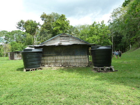 The
archaeologists lived on site for months at a time. Access was very poor
for a long time so that when they got there, they stayed there with
supplies coming in every few weeks or so. Their source of water was
rainfall off the metal roofs into these large tanks.
The
archaeologists lived on site for months at a time. Access was very poor
for a long time so that when they got there, they stayed there with
supplies coming in every few weeks or so. Their source of water was
rainfall off the metal roofs into these large tanks.
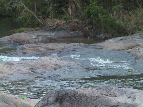 After a long hike through
the extensive complex we boarded the busses for the return trip. About
an hour's ride back down the road, we stopped at the Rio On pools, a
spot where a river flows over some rock formations and makes small
rapids, falls and pools. This has long been a favorite swimming spot
and the whole group got into the river to play. The water temperature
was just right and the rocks were very slippery, resulting in some fun
rides down the small rapids and then swimming in the larger pools.
After a long hike through
the extensive complex we boarded the busses for the return trip. About
an hour's ride back down the road, we stopped at the Rio On pools, a
spot where a river flows over some rock formations and makes small
rapids, falls and pools. This has long been a favorite swimming spot
and the whole group got into the river to play. The water temperature
was just right and the rocks were very slippery, resulting in some fun
rides down the small rapids and then swimming in the larger pools.
We got back to San Ignacio well after dark, got some dinner at
Hode's and simply crashed.
This morning, Sunday July 4, we slept in and then got breakfast on
our own (rolls we had purchased in town a couple of days before) and
then settled down to download and sort photos and write our blogs
before we forgot what happened.
Sandy and I took a walk toward the back of the Midas Resort, past
the last cabins through some mosquito infested grassland and forest to
the river that flows through San Ignacio. The resort claims that river
swimming is a "feature" of the resort, but I would not swim in that
muddy river.
The work plan for the upcoming week has been posted. Breakfast is at
0600 and we leave for the various sites at 0700. Return is in the late
afternoon and dinner is at 1900. Some evenings have a lecture at 2000.
We'll have to get up at 0530 to make breakfast so I assume that after
the lecture and then a shower it will be time to hit the sack.
If things go like last year, several of the students will be
drinking late into the night and then they will be nearly useless the
next day.
There have been mosquitos around, we are getting bit a few times
each day. If it doesn't get any worse than that, we will count
ourselves lucky. Kaiser prescribed an anti-malaria drug of some kind,
we've been taking it since 2 days before we left. Malaria is not a big
problem around here, but it does exist and getting it is bad.
Sandy bought an electric bug repellant device that she found at
Costco. It has a little insert that evaporates a small amount of fluid
and then a battery driven fan exhausts the stuff in a vapor cloud
around the wearer. We'll see how well that thing works tomorrow. It's
supposed to be effective for 12 hours of use. I don't know how long the
AA batteries that run the fan will last. In case it is ineffective, I
have a bottle of 100% DEET too. That WILL work but at the cost of
getting a little sticky. A DEET covered body collects dust big time. I
learned that last year.
Monday, July 5, 2010, San Ignacio, Belize, about 1800 CST
(GMT-6)
Today was the first work day since we got here. The schedule was up
at 0600 and over to breakfast by 0630. At 0700, the busses left for the
various sites that are active this year. There is a break for lunch and
then home late in the afternoon.
 We drove in that same
blue bus for close to an hour to get to the site which is on a forested
hill in Mennonite farming land. The site is called El Aguacate. We got
off the bus and were attacked by swarming mosquitos. We had to walk
through the swarm for about a half a mile to get to the site. The
further we got, the few mosquitos we found, but there were still a
lot.
We drove in that same
blue bus for close to an hour to get to the site which is on a forested
hill in Mennonite farming land. The site is called El Aguacate. We got
off the bus and were attacked by swarming mosquitos. We had to walk
through the swarm for about a half a mile to get to the site. The
further we got, the few mosquitos we found, but there were still a
lot.
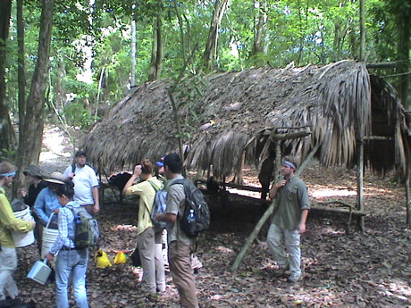
There was a simple rain shed at the site and another under
construction. The forest was pretty tall and there was little direct
sunlight.
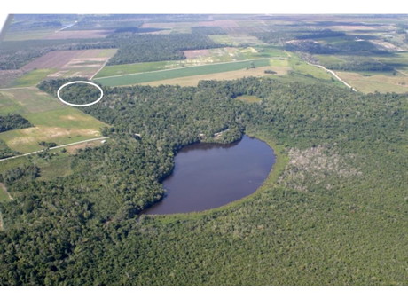 The El Aguacate site is in a small section of
forest surrounded by Mennonite farmlands. The lake in the UCLA UMAP
(UCLA Maya Archaeological Project) photo is the primary source of the
cloud of mosquitos at the site. I found this photo on the UMAP website. More
information about the project can be found at the link.
The El Aguacate site is in a small section of
forest surrounded by Mennonite farmlands. The lake in the UCLA UMAP
(UCLA Maya Archaeological Project) photo is the primary source of the
cloud of mosquitos at the site. I found this photo on the UMAP website. More
information about the project can be found at the link.
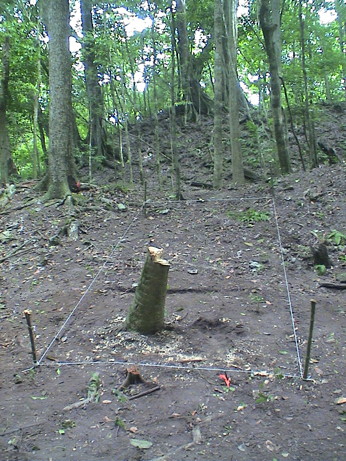 I got
assigned to this unit. The students were first assigned to lay out
simple 2 x 2 meter units on a flat patch of ground for time trial
practice. I helped one group through the first one, then stood back and
watched them on the 2nd pass. They were quick studies. Then I helped Mo
and Joe extend the real 2 x 2 unit into a 2 x 5 unit that was placed in
the assumed entrance way to a potential Maya structure. The structures
are buried under mounds that have a very peculiar shape and are
unlikely to be natural, but nothing of the structures shows now except
for a few suspicions looking surface stones. The palm tree stump was
quickly removed and the students got down to work. From the immediate
finds of pottery shards and other small artifacts, it is pretty obvious
that there is something here.
I got
assigned to this unit. The students were first assigned to lay out
simple 2 x 2 meter units on a flat patch of ground for time trial
practice. I helped one group through the first one, then stood back and
watched them on the 2nd pass. They were quick studies. Then I helped Mo
and Joe extend the real 2 x 2 unit into a 2 x 5 unit that was placed in
the assumed entrance way to a potential Maya structure. The structures
are buried under mounds that have a very peculiar shape and are
unlikely to be natural, but nothing of the structures shows now except
for a few suspicions looking surface stones. The palm tree stump was
quickly removed and the students got down to work. From the immediate
finds of pottery shards and other small artifacts, it is pretty obvious
that there is something here.
The students were pretty adept at excavating and really didn't need
help. Besides, I found that my back wasn't going to let me to much
useful work. Instead, I walked around the site with Sandy's GPS data
logger and an iPod touch running Sandy's data logging software to mark
and record GPS coordinates for the master and two other secondary
datums for the site. I also recorded the southwest corner of all five
units that had been opened. The site has already been shot with a Total
Station surveying device so that the project knows the relative
positions of each of the units with much better accuracy that GPS could
provide, but this data will serve to test Sandy's software and methods
for logging GPS data.
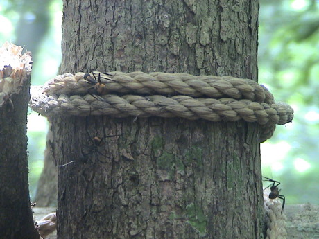 There were lots of
"bullet" ants on the site. They guys are pretty big as ants go, those
ropes are about 1/2". They are called bullet ants because that is what
is said that they feel like of one gets bit. I declined to test the
claim.
There were lots of
"bullet" ants on the site. They guys are pretty big as ants go, those
ropes are about 1/2". They are called bullet ants because that is what
is said that they feel like of one gets bit. I declined to test the
claim.
There are also much smaller fire ants here, but we didn't run afoul
of any. I also found some trails of leaf cutter ants. These ants cut
little roadways about 3" wide in the forest litter and then haul little
bits of green leaf material down their roads back to their nests.
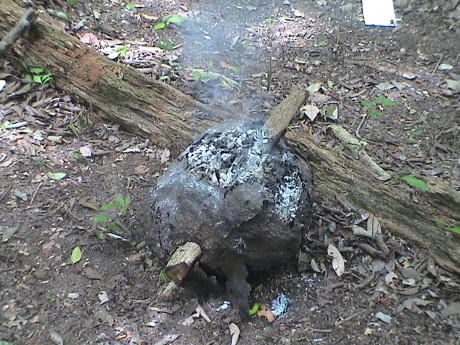 The
mosquitos were pretty bothersome. Lots of DEET was in use to ward them
off. However, the local laborers have another method. This is a
smoldering termite nest. These termites build there nests on the trunks
and branches of trees and the nests are easily cut down. When set
alight, the smoke tends to drive off the mosquitos. Just standing in
the smoke for a little while will get enough smoke into your clothes to
provide some protection for maybe an hour. It seemed to work some. I
was also wearing a little fan powered device that enveloped me in a
cloud of repellant vapor. That seemed to work too as I didn't have the
swarms around me like some of the students did. I also covered all my
exposed skin with 98% DEET. I still got some bites though.
The
mosquitos were pretty bothersome. Lots of DEET was in use to ward them
off. However, the local laborers have another method. This is a
smoldering termite nest. These termites build there nests on the trunks
and branches of trees and the nests are easily cut down. When set
alight, the smoke tends to drive off the mosquitos. Just standing in
the smoke for a little while will get enough smoke into your clothes to
provide some protection for maybe an hour. It seemed to work some. I
was also wearing a little fan powered device that enveloped me in a
cloud of repellant vapor. That seemed to work too as I didn't have the
swarms around me like some of the students did. I also covered all my
exposed skin with 98% DEET. I still got some bites though.
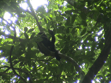 A group of monkeys
moved into the canopy above us. This is a howler monkey, there were
about 8 of these. There was also a smaller, and faster, spider monkey
in the group. He was much harder to take pictures of as the spider
monkeys move much more quickly than the howlers.
A group of monkeys
moved into the canopy above us. This is a howler monkey, there were
about 8 of these. There was also a smaller, and faster, spider monkey
in the group. He was much harder to take pictures of as the spider
monkeys move much more quickly than the howlers.
About noon, Sam brought Sandy around to see the site. I took
advantage of the visit to hitch an early ride home as my back was
staring to get pretty sore from standing all morning. I guess that I am
not cut out for much more field work.
We came home, stopped by the lab to pick up the stuff that Sandy
left there this morning and then walked a half mile or so back to
Hode's. Sandy ate her lunch and got a cold beer. I had eaten my box
lunch at the site and just got a cold grape Fanta. We walked back to
the Midas Resort and promptly crashed.
A thunderstorm came through about 1700 and the thunder and rain on
the tin roof woke me up so I settled down to write in this blog.
I think that tomorrow I'll offer myself up for lab duty where I can
at least sit for awhile and not do any heavy lifting.
Tuesday, July 6, 2010, San Ignacio, Belize, about 2000 CST
(GMT-6)
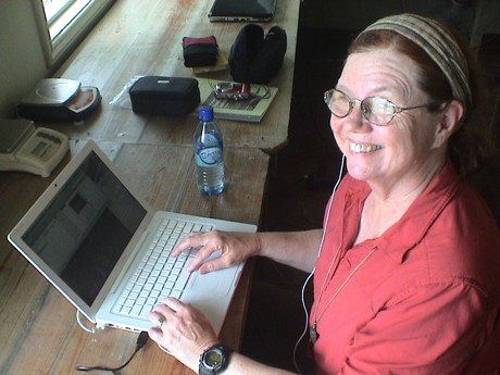 The reason that we came here
was for Sandy to help the project with their mapping database. She is
hard at work in the lab dealing photos here. Much of the mapping work
will be done after we get home as she needed a bunch of files from the
project computers. I was in the lab today because my back hurt from all
the standing at the site yesterday. I was still pretty sore. I hurt my
lower back last year and it hasn't completely recovered yet.
The reason that we came here
was for Sandy to help the project with their mapping database. She is
hard at work in the lab dealing photos here. Much of the mapping work
will be done after we get home as she needed a bunch of files from the
project computers. I was in the lab today because my back hurt from all
the standing at the site yesterday. I was still pretty sore. I hurt my
lower back last year and it hasn't completely recovered yet.
The lab itself is just a two story house that the project rents all
year around to use as a lab while the project is active and to use for
storage during the rest of the year. Nobody actually lives there. The
lower level is a basement where the excavation equipment is stored when
not in use. The upper story is where most of the work gets done. It can
also be used as a domestic residence for a few people during the
periods just before and after the project is active.
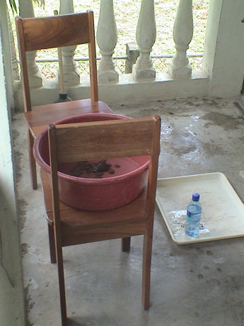 Since I was there,
I went to work washing artifacts that had been collected yesterday.
There were two other students there working on lithics (stone) and bone
samples. I was doing the ceramic samples, all pot shards. In that tub
is a pile of broken pottery soaking to soften the dirt attached to
them. A few minutes after this photo was taken, I used my fingers and a
toothbrush to clean off all the dirt and crud from each piece so that
they could be counted, weighted (as a group), categorized and
cataloged. Most of them will go into storage. Vanessa, the staff member
running the lab, will be attempting to reconstruct some of the samples
into a partial pot. Yesterday, one whole side of a pot was found in
situ as a pot smash in the unit pictured above. She'll be trying to put
that one back together.
Since I was there,
I went to work washing artifacts that had been collected yesterday.
There were two other students there working on lithics (stone) and bone
samples. I was doing the ceramic samples, all pot shards. In that tub
is a pile of broken pottery soaking to soften the dirt attached to
them. A few minutes after this photo was taken, I used my fingers and a
toothbrush to clean off all the dirt and crud from each piece so that
they could be counted, weighted (as a group), categorized and
cataloged. Most of them will go into storage. Vanessa, the staff member
running the lab, will be attempting to reconstruct some of the samples
into a partial pot. Yesterday, one whole side of a pot was found in
situ as a pot smash in the unit pictured above. She'll be trying to put
that one back together.
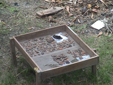 I had cleaned most
of the samples earlier and they are sitting on a drying screen in the
backyard of the lab. Many of the pieces are not very big and most don't
have a lot of value as they were not associated with other pieces.
However, the quantity of pieces that came out of the unit provides some
information as to the type and intensity of occupation that existed
based on the pieces that were left behind.
I had cleaned most
of the samples earlier and they are sitting on a drying screen in the
backyard of the lab. Many of the pieces are not very big and most don't
have a lot of value as they were not associated with other pieces.
However, the quantity of pieces that came out of the unit provides some
information as to the type and intensity of occupation that existed
based on the pieces that were left behind.
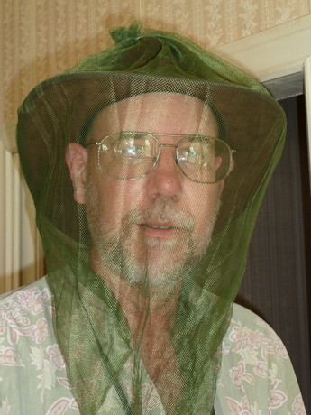 After all
the artifacts were done, I sat down to make some mosquito masks out of
a large mosquito net that we had and didn't need. I am not much of a
seamstress, but I managed to make two masks, a small one and a larger
one, that may be serviceable in the field. I gave them to Mo and Joe
during dinner for them to test. We have lots more material if the
students want to make more. I stitched them using mint flavored dental
floss.
After all
the artifacts were done, I sat down to make some mosquito masks out of
a large mosquito net that we had and didn't need. I am not much of a
seamstress, but I managed to make two masks, a small one and a larger
one, that may be serviceable in the field. I gave them to Mo and Joe
during dinner for them to test. We have lots more material if the
students want to make more. I stitched them using mint flavored dental
floss.
Wednesday, July 7, 2010, San Ignacio, Belize, about 1500 CST
(GMT-6)
Last night at dinner, I gave the two masks to Mo and Joe to test at
El Aguacate. This morning, they scared up some more mosquito net and
apparently there is a plan afoot to make more.
I spent the day in the lab again sewing five more mosquito masks.
There were enough students there to do the cleaning and cataloging so I
didn't mess with any artifacts today.
Sandy is building a database of project material. She spent much of
yesterday sorting through photographs from last year and identifying
what they were. Today, we fired up an HP scanner, which worked fine
with her MacBook, and she started scanning hardcopy from the reports
left from last year. The plan is to put this stuff into Google Docs in
some fashion to make access to the material much easier. I came back o
the room at about 1400. Sandy will stay there until the lab closes
scanning the archived material.
Just before the lunch break, Sandy and I took a walk into Santa
Elena to a bakery just a little ways from the other end of the "low"
bridge across river. We got some rolls and other pastry stuff and
walked back. It was probably about a mile each way from there to the
lab and it was hot. However, the freshly baked stuff was worth it.
Thursday, July 8, 2010, San Ignacio, Belize, about 1430 CST
(GMT-6)
It rained pretty hard last night and for much of the morning. It's
really loud on a tin roof.
Today was much the same as yesterday, except cooler and more humid.
Sandy and I went to the lab after breakfast and did pretty much the
same things as yesterday. She was scanning hardcopy of project records
from last year and I was making more mosquito masks. Last night, I got
a report back from the field that the two initial ones worked well and
I got "orders" for 10 more. I had already made five yesterday, those
went to the field today. I made eight more today. I can make 4 or maybe
5 more with the materials that I have.
I left Sandy in the lab to work on more scanning and I walked back
to Midas to shower, dry off and relax. I am currently soaking in sweat
and a cold shower will be coming up right after I upload this
update.
Friday, July 9, 2010, San Ignacio, Belize, about 1600 CST
(GMT-6)
Sandy and I spent the morning of our last "work" day with the
project back in the lab doing the same stuff as yesterday and the day
before. I made up the last 4 insect masks from the material I had.
Sandy finished scanning much of the material that was left over from
last year. After lunch, with the lab work done, we elected to visit
Cahal Pech.
 Cahal Pech, or "city of
ticks" (because it was in a cow pasture that was full of ticks) is a
smallish site that has been in work for several decades. It sits on a
hill just south of San Ignacio. The site was in use for a long time but
appears to have been abandoned around 850 AD.
Cahal Pech, or "city of
ticks" (because it was in a cow pasture that was full of ticks) is a
smallish site that has been in work for several decades. It sits on a
hill just south of San Ignacio. The site was in use for a long time but
appears to have been abandoned around 850 AD.
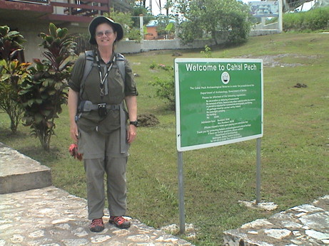
We didn't know exactly where the site was so we took a taxi from the
center of town to get there, a $2.50 US ride.
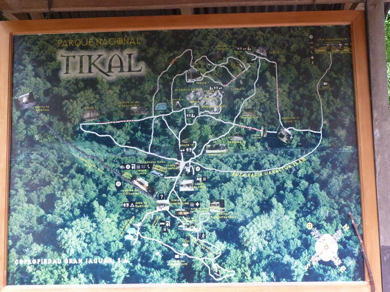
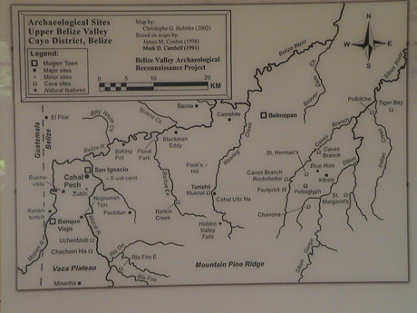 This map shows the
locations of sites in this area. Caracol is not on this map, it is too
far south. We've been to Cahal Pech and Xunantunich. El Aguacate would
be underneath the map key or slightly north. Tikal is in Guatemala, off
the western edge of the map.
This map shows the
locations of sites in this area. Caracol is not on this map, it is too
far south. We've been to Cahal Pech and Xunantunich. El Aguacate would
be underneath the map key or slightly north. Tikal is in Guatemala, off
the western edge of the map.
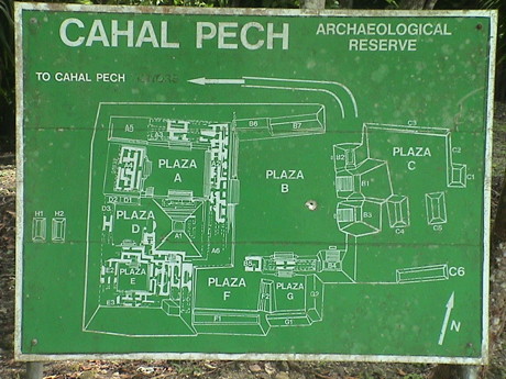 Cahal Pech is typical
Maya, with squarish plazas surrounded by temples and domestic
structures. The tallest structure, probably a temple, is just south of
Plaza A.
Cahal Pech is typical
Maya, with squarish plazas surrounded by temples and domestic
structures. The tallest structure, probably a temple, is just south of
Plaza A.
There are several unexcavated mounds around some of the plazas that
clearly have structures underneath. I have no clue if there is a plan
to excavate them.
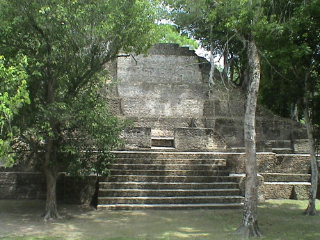 This is the temple
as viewed from the north side of Plaza A. The rest of the plaza is
ringed in domestic spaces.
This is the temple
as viewed from the north side of Plaza A. The rest of the plaza is
ringed in domestic spaces.
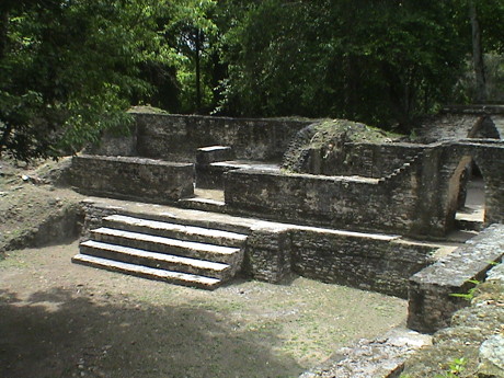 A typical domestic space is
a doorway facing the plaza and a small area with a stone bench inside.
There would be some sort of bedding on the bench. The unit was probably
used mostly for sleeping as there isn't room for much else. Cooking was
probably done out of doors. It is not known how the open units were all
covered. There were some domestic units in other parts of the site that
were covered with a corbeled stone roof, but these were clearly rebuilt
as there were timber lintels above the doors.
A typical domestic space is
a doorway facing the plaza and a small area with a stone bench inside.
There would be some sort of bedding on the bench. The unit was probably
used mostly for sleeping as there isn't room for much else. Cooking was
probably done out of doors. It is not known how the open units were all
covered. There were some domestic units in other parts of the site that
were covered with a corbeled stone roof, but these were clearly rebuilt
as there were timber lintels above the doors.
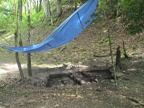 There is still some
active archaeology in process at Cahal Pech as there are several open
units on one part of the site. The tarps are probably to protect the
units from heavy rainfall.
There is still some
active archaeology in process at Cahal Pech as there are several open
units on one part of the site. The tarps are probably to protect the
units from heavy rainfall.
After we left Cahal Pech, we elected to walk back into and through
town to get to the Midas Resort which was on the north side of town. It
was a 2 mile walk, mostly downhill, back to Midas.
Saturday, July 10, 2010, San Ignacio, Belize, about 1700 CST
(GMT-6)
 Today we got up at
0600 again and went into town early for the "special" Saturday market.
There is a farmer's market in San Ignacio every day, but Saturday is
the "big" day. There is usually just produce there, on Saturday, all
the local vendors show up.
Today we got up at
0600 again and went into town early for the "special" Saturday market.
There is a farmer's market in San Ignacio every day, but Saturday is
the "big" day. There is usually just produce there, on Saturday, all
the local vendors show up.
This isn't like the flea markets that we usually gravitate to on
these trips. This one is for the locals so that there are no tourist
trinkets there but stuff that the locals would buy, like a stand full
of bras.
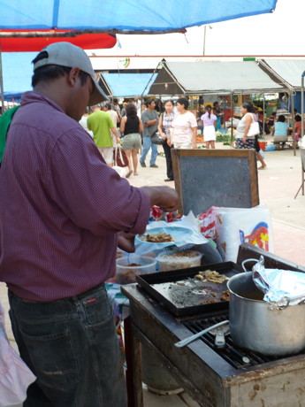
There are also prepared food vendors there too in large numbers.
They guy was cooking tacos. I had the very best pork taco I have ever
had for breakfast today.
Then we walked a short way back to Hode's to meet some folks for a
day trip to Tikal. Tikal is a very important Mayan site located in
Guatemala. It is a somewhat involved process just to get there so we
were planning on going with one of the groups from the project going to
Tikal. Most of the project was going to stay over two nights in Tikal.
We couldn't do that because our flight home would leave before they got
back. We went instead with a smaller group that was staying overnight.
We had planned to go part way with them and then split off for our own
day trip. We ended up going as far as the western border with them
where we split as one of them had to return to San Ignacio to retrieve
her passport.
The cab fare to get that far was $12.50 US. We had to pay $37.50 US
as an exit fee to get out of Belize. We'll have to pay that again
tomorrow at the airport. Then we had to pay $6 US for a Guatemala
entrance fee. Then we hired a private cab that would take us there,
wait for us and take us back to the border. That cost $70 US for the
round trip. It cost us $42 US to get into the park. We had lunch after
the tour of Tikal that was good and cost $16 US. I tipped the cab
driver $10. Then there was another $12.50 cab ride from the border back
to town. This was not a cheap day trip.
 The Tikal site itself has
been under excavation for about 50 years and it is big. Some of the
trails were marked in with walking time, the trail up there was 25
minutes from the ticket booth. We ended up making a loop that took us
just over 3 hours, just as much as our feet would stand.
The Tikal site itself has
been under excavation for about 50 years and it is big. Some of the
trails were marked in with walking time, the trail up there was 25
minutes from the ticket booth. We ended up making a loop that took us
just over 3 hours, just as much as our feet would stand.
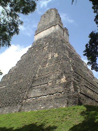 After
climbing jungle trails for about a half hour, the jungle opened up and
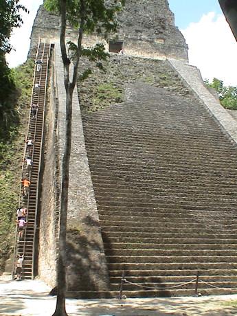
we saw this, the back of Temple 1. This thing is over 100 meters high
and has been here for some 2000 years.
After
climbing jungle trails for about a half hour, the jungle opened up and
we saw this, the back of Temple 1. This thing is over 100 meters high
and has been here for some 2000 years.
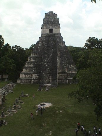 This is the front side of Temple 1 which faces the Grand Plaza. The
shot was taken later in the day from near the top of Temple 2, which
also faces the Grand Plaza. Climbing on Temple 1 was not allowed.
This is the front side of Temple 1 which faces the Grand Plaza. The
shot was taken later in the day from near the top of Temple 2, which
also faces the Grand Plaza. Climbing on Temple 1 was not allowed.
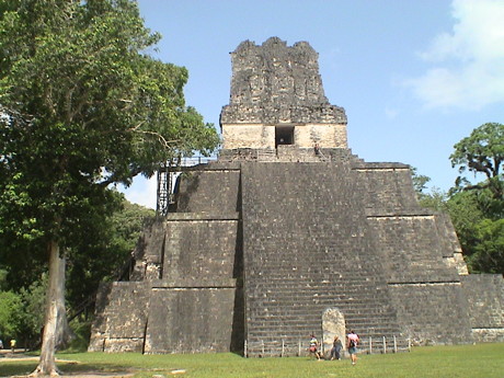 Temple 2 has
wooden stairs up the left side to a platform near the top. I climbed it
later in the day after we had walked most of the site. I didn't want to
blow out a knee before I had seen the place. As it turned out, it
wasn't a hard climb as the handrails helped a lot.
Temple 2 has
wooden stairs up the left side to a platform near the top. I climbed it
later in the day after we had walked most of the site. I didn't want to
blow out a knee before I had seen the place. As it turned out, it
wasn't a hard climb as the handrails helped a lot.
 Temple 5 is
another big one. This one also has stairs but they were steeper and
taller than the ones on Temple 2. I didn't even attempt to climb
it.
Temple 5 is
another big one. This one also has stairs but they were steeper and
taller than the ones on Temple 2. I didn't even attempt to climb
it.
There were lots of other smaller structures scattered about, some 60
of them have been identified and there are clearly more to find under
obvious mounds. We walked among them for about 5 miles within the park
according to the reading of my pedometer.
We had lunch before we got back in the taxi to ride the 125 km back
to the border. Part of the road was dirt, but fortunately most of it
was well paved. It started to rain part way back and the rain followed
us all the way back to San Ignacio. At least the weather was good while
were at Tikal.
Tomorrow, we get check out at noon after getting some lunch at
Hode's. A taxi will be waiting for us at noon for a direct trip to the
airport for $75 US. We're not going to mess with the public bus this
time. It only runs every hour, or maybe two, on Sunday and it'll be
crowded and would probably take 3 to 4 hours including the taxi ride
from the Belize City bus terminal and the airport. In the taxi, we'll
get there somewhere around 1400 to catch our 1720 flight on TACA.
Sunday, July 11, 2010, San Ignacio, Belize, about 0830 CST
(GMT-6)
We're packing up to leave today at about noon. It is cooler today
than it has been, primarily because of the thundershowers. We expect
intermittent rain all the way to Belize City. This will be last entry
in this blog until a wrap up sometime after we get home about midnight
PDT tonight.
Monday, July 12, 2010, Torrance, CA, about 0900 PDTT
(GMT-7)
We checked out and met our taxi at noon after getting some lunch at Hode's. The ride to the airport took a little less than two hours so we had still three hours to wait for the flight. Our flight on TACA was the 2nd to last flight out of the airport that day so that before we left, the airport staff was closing everything down. The flight left about 20 min early so everybody must have showed up.
We had to go through security again in San Salvador and they took my empty water bottles. They were just reused plastic bottles, but I was still irritated. They also insisted on checking my carry on bag but when we got on the plane, there would have been plenty of room for the dozen or so bags that they checked.
We got home about 0100 this morning and I crashed virtually immediately. Sandy's watch alarm was not turned off so it woke me up at 0500 and I didn't get back to sleep so I just started putting my home life back together before going to work.
It was a good trip overall. This place is COLD in comparison to Belize but it least it isn't humid.
This page has been accessed times since July 1, 2010
© 2010 George Schreyer
Created July 1, 2010
Last Updated July 12, 2010