George and Sandy's 2005 Hawaii Visit
Friday, February 4, 2005, about 0730 HST
Sandy and I are on our way to Hawai'i again, this time for only four
days. The purpose of our trip is to visit Katie at school and to see
the eruption of the Kilauea volcano. Sandy figured that United Airlines
will enter Chapter 11 pretty soon so that she also wanted to burn her
frequent flyer miles before the airline voids them.
Due to the flights that we could get on the frequent flyer program,
we left LAX at 0630 and headed for San Francisco. After an hour layover
there, we boarded a flight bound for Honolulu. The movie (Sky Captain)
just started so we'll be watching that.
We'll get in a little after noon. The plan is to find our hotel and
then pick up Katie and get dinner. Saturday, we fly to the big island
to see the volcano. Sunday, we tour Oahu with Katie. Monday, Katie goes
back to school and we tour the north side of the island. Late Monday
night, we fly home arriving at about 0600 Tuesday.
Friday, February 4, 2005, about 1830 HST
 We arrived ok,
got our car and found our hotel with the aid of Sandy's new GPS
navigation toy. Our room wasn't ready so we went out walking for an
hour or so. Right across the street from the Ohana West hotel in
Waikiki was a place called the International Market Place. This was a
maze of little trinket stands and shops. It took a full hour to
maneuver though that place. Later, we drove up to UH Manoa to pick up
Katie. Besides taking her to dinner, we need to leave very early
tomorrow to catch our flight to Hilo so that Katie will be staying with
us in our hotel so that we can avoid the time it would take to pick her
up tomorrow morning.
We arrived ok,
got our car and found our hotel with the aid of Sandy's new GPS
navigation toy. Our room wasn't ready so we went out walking for an
hour or so. Right across the street from the Ohana West hotel in
Waikiki was a place called the International Market Place. This was a
maze of little trinket stands and shops. It took a full hour to
maneuver though that place. Later, we drove up to UH Manoa to pick up
Katie. Besides taking her to dinner, we need to leave very early
tomorrow to catch our flight to Hilo so that Katie will be staying with
us in our hotel so that we can avoid the time it would take to pick her
up tomorrow morning.
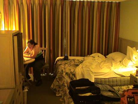
This pic is actually from our last day, Sandy is reviewing some
video that she took with her new Canon still camera. She was obviously
pleased. The room was a pretty standard hotel room but it did have a
kitchenette which came in handy.
Sunday, February 6, 2005, about 0500 HST
It about 5 AM and I'm awake, as usual. Our hotel room is right
behind the elevators and they don't make a lot of noise, but it goes
all night long.
Yesterday, we got up at 0430 to get ready to fly to Hilo. The flight
left at 0650 and we still had to get up and ready, find the airport,
return the rental car (a Grand Prix), find the terminal and clear
security. It turns out that this happened pretty efficiently and we
spent over an hour at the (nearly deserted) airport waiting for our
DeHavilland dash 8. The twin turbo puddle jumper took us to Hilo where
we rented yet another car, a Dodge Magnum. It was a 29 mile drive to
the Hawai'i Volcanos National Park entrance, and another 25 miles or so
down Chain of Craters road to the end where to the hike to the lava
flow started. I was pleasantly surprise to find that there were only a
dozen cars to so there. I expected hundreds.
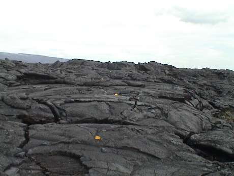
Last time we were here, there was a little red lava oozing about a
mile from the end of the road. This time Kilauea was in full eruption
and lava was flowing all the way to the sea in several locations. The
flows even made the national news, we saw a report on CNN Headline news
when we got back to the hotel that night. The flow we saw wasn't nearly
as impressive as the view on the news, but it was impressive enough.
The really big flows were too inaccessible to casual hikers. There were
other flows that we could have hiked to as well, but we expended most
of our energy just getting to and from the closest one. It was wise to
have only gone that far.
Also unlike 2003, it was early in the morning (about 0930) when we
started our hike, it was overcast (no direct sun) and the lava fields
that we hiked through were cool so that the temperature was probably
less than 70F (last time it was pushing 100F). However, the hike was
longer. The signs said 1.5 miles to the nearest flow and that the round
trip would take at least 2 hours. We hiked out the road to the spot
where we walked inland last time and found that what had been clear
road last time was a lava flow from just after we left. The majority of
the hike this day was cross country across the lava relatively new
flows.
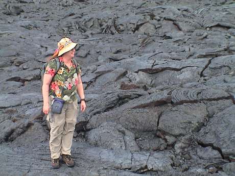
 This is hard hiking, we had to watch every step and
the footing was very irregular. One bad step could lead to a sprained
ankle, a hyper-extended knee and/or lacerations. These trail markers
extended only a little way out on the flow. After that, there were some
highway construction markers placed at high spots every few hundred
yards so that you could roughy see where you should be going. The
actual path was optional, but it was all bad. One could sub-optimize a
fairly good path for a short distance by winding all around but in the
long run it was better just to pick a nearly straight line and go for
it.
This is hard hiking, we had to watch every step and
the footing was very irregular. One bad step could lead to a sprained
ankle, a hyper-extended knee and/or lacerations. These trail markers
extended only a little way out on the flow. After that, there were some
highway construction markers placed at high spots every few hundred
yards so that you could roughy see where you should be going. The
actual path was optional, but it was all bad. One could sub-optimize a
fairly good path for a short distance by winding all around but in the
long run it was better just to pick a nearly straight line and go for
it.
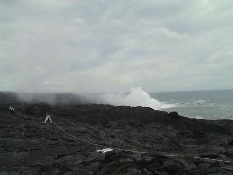 In the
distance, we could see steam rising from the shoreline. The rope line
on the right is to keep visitors from getting too close to the bench,
or the region above the surf. The benches get regularly undercut by the
surf and they often collapse into the sea. There have been people hurt
and killed here while standing on a bench that collapses. Also, when
the lava hits the water, the heat and chemicals in the lava interact
with the salt in the ocean water to make a weak hydrochloric acid. This
can be tough on the eyes and the lungs. This doesn't count the hydrogen
sulfide (rotten egg smell) that normally exists in lava.
In the
distance, we could see steam rising from the shoreline. The rope line
on the right is to keep visitors from getting too close to the bench,
or the region above the surf. The benches get regularly undercut by the
surf and they often collapse into the sea. There have been people hurt
and killed here while standing on a bench that collapses. Also, when
the lava hits the water, the heat and chemicals in the lava interact
with the salt in the ocean water to make a weak hydrochloric acid. This
can be tough on the eyes and the lungs. This doesn't count the hydrogen
sulfide (rotten egg smell) that normally exists in lava.
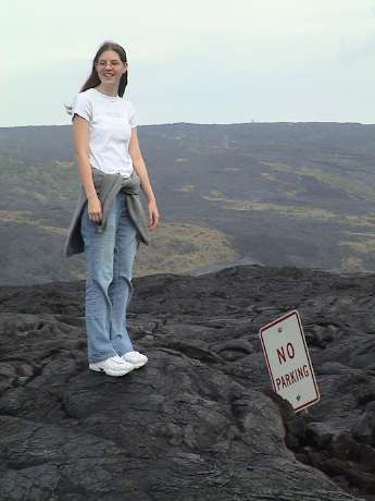 Our
overland route took us roughly along the old road. Occasionally we
would find evidence that a road was actually under there. The sign is a
little redundant at this point.
Our
overland route took us roughly along the old road. Occasionally we
would find evidence that a road was actually under there. The sign is a
little redundant at this point.
 Sandy is
standing on a typical flow on the way out. It was up, down, around and
over the whole way.
Sandy is
standing on a typical flow on the way out. It was up, down, around and
over the whole way.
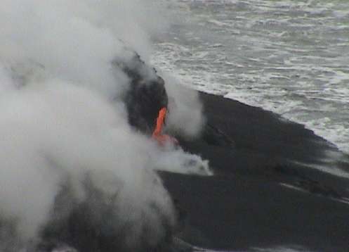 This is what
we came to see. We couldn't get much closer due to the steam and fumes.
There was much more happening further up the coast, but we were already
tired and we still had to hike back.
This is what
we came to see. We couldn't get much closer due to the steam and fumes.
There was much more happening further up the coast, but we were already
tired and we still had to hike back.
Between the steam and the surf, timing these photos was difficult.
We spent about an hour there waiting for the "good" shots.
By the time that we got back to the car, it was almost 1300. The
temperature had warmed up quite a bit. We'd spent 3 1/2 hours on a 2
hour hike and we were hot, tired, sore and thirsty. We'd taken 2 almost quarts per person and drank all of it, mostly on the way back. There
was a vendor at the end of the road selling ice cold water so we bought
some and drank most of that on the spot.
Katie virtually passed out in the back seat so that we decided that
it wasn't a good time to tour the rest of the park so we drove back to
Hilo to get lunch, do some shopping and then wait for our flight back
to Honolulu where we picked up our 3rd rental car for the day (a Chevy
Impala this time) and drove back to the hotel.
After Katie picked up her stuff, I dropped Katie off in her dorm.
She had gone through Internet withdrawal the night before. We did have
dial up access in the hotel room and she used it for hours, but she was
missing her high speed internet service. I had leftovers of last
night's dinner, Sandy had a bagel and we both crashed.
Honolulu streets are a maze. I got lost getting back from Katie's
dorm. There are many one way streets, no left turns (where you should
be able to make a left turn) and, of course, some Hawaiian street
names. I did manage to make it back to the hotel in good order
though.
It's now a little after 0600 as I finish typing this last section.
Sandy is still sleeping and I'm headed back to bed to try to catch a
few more winks.
The plan for today is to tour geologically significant regions of
Oahu. I will be the driver, Sandy and Katie are setting the agenda so
I'll know later exactly were we are going.
Sunday, February 6, 2005, 1635 HST
We didn't get to many geologically significant regions. We did get
to Costco and Diamond Head.
After a late start, we picked up Katie at her dorm and headed for
the Costco store that was out past the airport.... at least that where
the phone book said it was. Even with a paper map and Sandy's GPS
navigation system, we got lost several times trying to find it. I
couldn't seem to get off the freeways. Every time we tried to get off,
we ended up on another freeway. When we did get off, we ran into guard
shacks at two different military installations by turning onto roads
that were indicated in the mapping software. At the second guard shack,
the guard actually knew where the Costco wasn't. It had closed down and
moved some time before. The new Honolulu Costco was back in town, much
closer to where we started than where we were. Katie was starving by
this time and she really wanted Sandy to turn off the damn computer and
just find someplace to eat.
In trying to get back to town, we passed a Wendy's that I didn't see
until it was too late to pull in and then Katie passed on a MacDonald's
that I didn't see in time anyway. Then we sort of ran into the Costco
store and got lunch there. After stocking up on non-perishables for
Katie and some really nice Hawaiian shirts for me, we drove back to
Katie's dorm to drop the stuff off.
These are really nice shirts. I've first found them at the Costco in
Kona, Hawai'i, then in the Costco store in Hawthorne CA (they had them
for only a short time), now in the Costco store in Honolulu. They're
made by Cooke Street here in Honolulu and cost $18. Similar shirts sold
all over the islands here run much more.
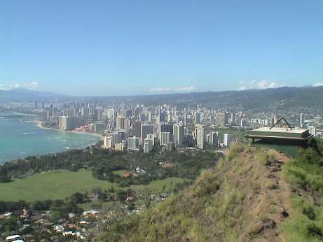 We then drove to Diamond Head for a hike.
Katie had not been there and wanted to see it. This is a state park
that was converted from military use. Diamond Head is a volcanic crater
right next to Waikiki. On the seaward edge, it is about 760 ft high and
commands and excellent view. The military figured this out long ago and
before WWI, they built an observation and targeting bunker for a series
of artillery batteries scattered around Diamond Head. None of them ever
fired a shot in wartime.
We then drove to Diamond Head for a hike.
Katie had not been there and wanted to see it. This is a state park
that was converted from military use. Diamond Head is a volcanic crater
right next to Waikiki. On the seaward edge, it is about 760 ft high and
commands and excellent view. The military figured this out long ago and
before WWI, they built an observation and targeting bunker for a series
of artillery batteries scattered around Diamond Head. None of them ever
fired a shot in wartime.
From the crater floor, it is about a 500 ft climb on a 0.8 mile
trail to reach the observation post. The last part of the trail is a
series of 74 concrete steps, a 225 ft tunnel, another 99 steps and then
3 flights up a circular stairway to the post. It is a pretty stiff
climb but the view is excellent.
After the hike, we took Katie back to her dorm and we retired to the
hotel to relax. This time, I found the "right" way to go the 1.6 miles
from UH to Waikiki. We got dinner near the hotel in a Carib/Mex place.
It was good. Tomorrow, we plan to sleep in and then tour the north
shore of Oahu. Our flight leaves Honolulu at 2200 so we'll have plenty
of time.
Monday, February 7, 2005, 2035 HST
We've made it to the Honolulu airport for our red-eye home. The
flight leaves in an hour and a half.
We checked out of the hotel at about 1100 this morning and then
drove in the direction of Diamond Head to start our trip around the
island. Sandy had a paper that was published in the Geological Society
of America that described a field trip along a short section of highway
72 in the south east corner of Oahu. We made most of the stops and took
lots of pictures.
We proceeded north on 72 to the town of Waimanalo. We found a local
lunch spot along the road. It looked pretty ragged, but I guessed that
it was good because there were lots of locals hanging out front. Indeed
it was a very good lunch for $5.50 (BBQ chicken, rice and macaroni
salad).
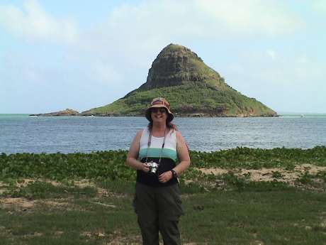 Traveling along the coast, we stopped at nearly every
beach park along the way. This photo is of Sandy with an island called
Chinaman's Hat in the background. We were at a quite nice beach park
called Kualoa Regional Park. We spent quite a bit of time just
beachcombing and harassing the sand crabs on the beach.
Traveling along the coast, we stopped at nearly every
beach park along the way. This photo is of Sandy with an island called
Chinaman's Hat in the background. We were at a quite nice beach park
called Kualoa Regional Park. We spent quite a bit of time just
beachcombing and harassing the sand crabs on the beach.
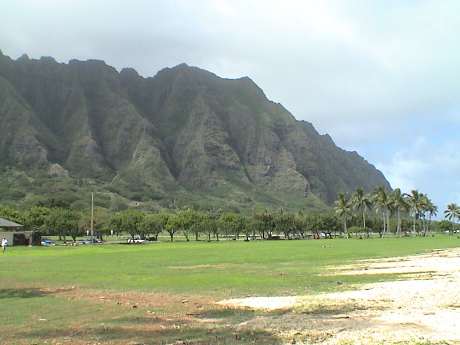 These mountains are typical of the whole range
that runs up the east coast of Oahu. This shot was also taken at Kualoa
beach.
These mountains are typical of the whole range
that runs up the east coast of Oahu. This shot was also taken at Kualoa
beach.
Our final beach stop was Waimea Bay where Sandy napped for a bit.
Since there is no through road down the west coast of Oahu, we turned
south on 99 to return to Honolulu through the central valley of Oahu.
Part way down, we ran across the Dole Plantation. This is a kind of a
tourist trap store but I figured that if they didn't have the pineapple
cutter that I have been looking for for months, nobody would have it.
They did and I brought one home along with some dried pineapple,
coconut and mixed fruits.
The trip to Honolulu was a quick one from there because it was
mostly freeway. Hawai'i has "interstate" highways which are regulation
freeways but obviously don't cross a state line. We got into Honolulu
about 5 hours ahead of our flight so we drove to the Ala Moana mall to
burn some time. At least the parking was free.
The Ala Moana mall is a regulation shopping mall with tons of trendy
stores. We spent some time in the Apple store surfing the net and then
got dinner at the food court. At 1930, it was time to head to the
airport. It took us just one hour to put gas in the rental car, get to
the airport, return the car, check a bag, clear security and make it to
the gate. It'll be a long flight home and I hope that I sleep through
most of it.
Wednesday, February 9, 2005, 1735 PST
Its a couple of days later, we obviously made it back ok. However, neither of us slept very much on the airplane. By the time we got home, it was after 0600. I tried to go back to sleep, but no joy. I went to work instead. By 1400, I was falling asleep and I came home to crash.
So ended our short visit to Hawai'i. It was an interesting trip but it was a little time compressed. Next time, we'll schedule a more relaxed pace.
This page has been accessed times since February 8, 2005
© 2005 George Schreyer
Created February 4, 2005
Last Updated February 8, 2005